Discovery Announces Positive Drilling Results from All Operations at Porcupine Complex
TORONTO, Nov. 06, 2025 (GLOBE NEWSWIRE) -- Discovery Silver Corp. (TSX: DSV, OTCQX: DSVSF) (“Discovery” or the “Company”) today to reported initial results from four key exploration projects at the Company’s Porcupine Complex, including Hoyle Pond Mine, Borden Mine and Pamour Mine, as well as at Owl Creek, a high-priority target located approximately three kilometres west of Hoyle Pond. The results include assays from a combined total of 85 holes1 (27,640 metres (“m”)), completed between April 2025 and October 2025, which are part of an overall 140,000 m program being completed. The Company also provided an update on recently initiated drilling programs at the Dome Mine and TVZ Zone adjacent to Hoyle Pond, two key growth projects which have the potential to significantly grow production from the Porcupine Complex.
Key Highlights
Excellent results from resource conversion and expansion drilling2
-
Hoyle Pond3: Multiple high-grade intercepts near lower limits of S Zone
- 23.95 gpt over 7.1m
- 9.88 gpt over 11.5m
- 86.09 gpt over 2.1m, including 360.00 gpt over 0.5m
- 150.00 gpt over 3.1m, including 302.00 gpt over 0.4m
- 35.98 gpt over 2.9m; and 11.65 gpt over 2.8m
-
Borden3: High-grade intersections along strike to northeast of Main Zone
- 11.48 gpt over 5.2m, including 15.49 gpt over 3.2m
- 9.41 gpt over 12.6m, including 19.29 gpt over 5.2m
- 15.61 gpt over 6.0m
- 13.88 gpt over 6.9m, including 18.99 gpt over 4.8m
-
Pamour4: Excellent drill results within and along strike of current resources in all three phases of pit design, including several holes with multiple intercepts
- Multiple intercepts:
1.44 gpt over 104.6m, 1.07 gpt over 54.5m
2.03 gpt over 25.8m, 2.18 gpt over 20.5m, 1.20 gpt over 37.8m
3.42 gpt over 19.9m, 1.47 gpt over 57.6m
1.85 gpt over 34.6m, 1.35 gpt over 15.5m
-
- Single intercepts:
48.82 gpt over 5.0m; 3.40 gpt over 39.8m;1.51 gpt over 38.3m;1.78 gpt
over 39.4m; 1.51 gpt over 34.2m; 1.40 gpt over 44.9m; 0.96 gpt over
86.6m; 1.32 gpt over 40.9m; 1.30 gpt over 27.3m
Multiple high-grade intersections at Owl Creek4 in close proximity to Hoyle Pond
-
- 4.08 gpt over 16.2m, including 9.81 gpt over 3.9m
- 4.14 gpt over 17.5m, including 6.48 over 10.0m
- 5.58 gpt over 5.2m, including 17.63 gpt over 1.1m
- 5.39 gpt over 11.0m
- 5.59 gpt over 6.0m
Drilling programs commenced at Dome and Hoyle Pond TVZ Zone
- 15 holes (959 m) were abandoned due to excessive deviations from the target.
- All assays are reported uncut.
- Intervals are reported using both true widths and core lengths.
- Intervals are reported using core lengths only.
Tony Makuch, Discovery’s CEO, commented: “The drill results announced today support our view that substantial gold remains to be identified at Discovery’s assets at Porcupine. At Hoyle Pond, drilling has continued to extend the S Zone to depth and identified new lenses of mineralization to the west of the existing resource. There also remain numerous attractive targets higher up in the mine to be evaluated during our current drill program. We are also very encouraged by multiple high-grade intersections at Owl Creek, approximately 3 km from Hoyle Pond, which highlight the significant potential for mineralization to extend far to the west. In addition, we recently commenced drilling at TVZ, a large zone directly adjacent to Hoyle Pond, which we expect will become an important new source of production. We are targeting approximately 25,000 m of drilling at TVZ by early next year as we work towards releasing an initial NI 43-101 resource for the project.
“Turning to Borden, drilling has clearly demonstrated the continued extension of the Main Zone and the potential for expansion to the northwest. Borden includes a massive 1,000 km2 land position that is largely unexplored outside of the current mining trend. At Pamour, favourable drill results within and along strike of resources in all three phases of the pit design highlight the opportunity we have to add significant new ounces and to grow the project through continued drilling.
“The re-development of Dome represents a game changer for our Porcupine operations. We are planning to drill approximately 7,500 m, and conduct further analysis of existing data and mineralization models, as we prepare to update the existing 11.0 million ounce inferred mineral resource, including converting a portion of this resource to the Indicated category. We are also working on a new pit design that would not require moving the mill, and would provide access to more than half of the current resource, supporting well over a decade of mining. A study on Dome is advancing which will establish a plan to resume open-pit operations and also evaluate the potential for future underground mining.”
Hoyle Pond Mine
Drilling at the Hoyle Pond Mine included a total of 23 holes (5,877m) to test the lower portion of the S Zone, the largest and highest-grade area of the mine. Of the holes drilled, 10 holes (567 m) were abandoned due to excessive deviation from the target.
The Hoyle Pond Mine is located approximately 20 km northeast of Timmins and in the east portion of the Hoyle Pond volcanic belt adjacent to a major northeast trending flexure and the 1060 fault. Mineralization at the mine occurs in multiple zones of quartz veining between surface and a depth of 2,000 metres along the trend of the main flexure. The S Zone, which is the main focus of the current drill program, lies in the lower east portion of the mine, just east of the 1060 fault (Figure 1).
The 13 holes being reported are the first phase of an overall 40,000 m drill program which is designed to convert and expand inferred resources on the lower and west sides of the S Zone between the 2100 and 2295 levels (Figure 2). All drilling was done from a series of platforms located on the 1860 level and on the north (hanging wall) side of the S Zone.
Drilling to depth includes five new holes near the bottom limit of the inferred resource, with results demonstrating similar grades, widths and grade continuity to previous drilling. Key intercepts from drilling include: 23.95 gpt over 7.1m in hole 27682; 9.88 gpt over 11.5m and 86.09 gpt over 2.1m, including 360.00 gpt over 0.5m, in hole 27701; 150.00 gpt over 1.3m, including 302.00 gpt over 0.4m, in hole 27657; and 9.55 gpt over 1.54m, including 36.3 gpt over 0.40m, in hole 27664 (Table 1).
Drilling to the west was focused between the 2100 and 2200 levels and resulted in a number of favourable intercepts that support the potential for new lenses of mineralization to occur west of the current resource. Key intercepts include: 35.98 gpt over 2.9m in hole 27653; 75.5 gpt over 1.0m and 11.65 gpt over 2.28m, including 31.30 gpt over 0.4m, in hole 27660; and 8.67 gpt over 1.67m, including 19.90 gpt over 0.7m, in hole 27654.
The program is continuing with four drills, which are focused on holes to depth and to the west side of the S Zone. Work is also in progress to develop a strategy for drilling further to the east and to depths of at least 2,500 m with options under consideration including drilling from a potential new exploration drift and drill platform near the 2000 level or Navi drilling from the 1860 level.
Borden Mine
Drilling at the Borden Mine included a total of 19 holes (4,360 m) to convert and expand resources in the northeast portion of the Main Zone which is the host for the majority of gold mineralization at the mine (Figures 3 and 4).
The Borden Mine is located approximately 190 km southwest of the Dome Mill, near to Chapleau and in the south portion of the Borden Lake Greenstone Belt. The Main Zone is an east-west trending structure located along the east - west trending Genesis Deformation Zone (GDZ) adjacent to a major contact between felsic gneiss and amphibolite. Work to date has traced the zone for a strike length of over 1.7 km along strike and indicates the zone is closely associated with quartz veining, biotite-garnet alteration and pyrite.
The holes reported today represent the first phase of a 30,000 m drill program at Borden, including 20,000 m of in-mine drilling designed to cover a 300 m strike length of the Main Zone near the current northeast limit of inferred resources, as well as 10,000 m of drilling focused on district targets around the mine. All in-mine drilling is being planned from cut outs located in the east portion of the 585- exploration drift, situated in the hanging wall of the zone.
Results of the program have been extremely positive and include: 11.48 gpt over 5.2m, including 15.49 gpt over 3.2m, in 585-00099; 9.41 gpt over 12.6m, including 19.29 gpt over 5.2m, in 585-00102; 13.88 gpt over 6.9m, including 18.99 gpt over 4.8m, in 585-00159; 6.15 gpt over 23.1m, including 13.21 gpt over 7.8m, in 585-00127; and 8.47 gpt over 8.2m, including 11.52 gpt over 4.6 m, in 585-00126 (Table 2).
From current interpretations, the Main Zone continues to track as planned with grades and widths that are similar to, or better than, the current resource model. These results, along with ongoing wide-spaced surface drilling, located up to 1.2 km to the northeast, establish the potential for further growth as drilling continues.
The program is continuing with three drills working to convert and extend resources. Planning is also in the final stages for a further extension of the exploration drift to the northeast, as well as for the mobilization of a surface drill to the gap between the end of the exploration drift and the wide-spaced surface holes to the northeast.
Pamour
Drilling at the Pamour Mine included a total of 32 holes (10,144 m) to test areas within and surrounding the large open-pit resource at the property, which includes 6.48 million tonnes grading 1.30 gpt (2.70 million ounces) in the Indicated category and 2.33 million tonnes grading 1.34 gpt (1.00 million ounces) in the Inferred category (Figure 5).
The Pamour Mine is located approximately 20 km east of Timmins on the north side of the Destor Porcupine Fault Zone and straddles the unconformity between Tisdale Group volcanics and Timiskaming sediments. Mineralization at the mine is closely associated with quartz veining, which can occur in single veins, vein arrays, stockworks as well as pyrite both along the unconformity and in volcanics to the north.
The holes drilled represent the first phase of a 40,000 m drill program designed to convert and extend inferred resources over the full strike length of the resource pit, which currently stands at approximately 2.3 km. Results from the program to date have been very positive (Table 3).
Significant results in the central portion, which overlie the phase 1 pit, include: 1.44 gpt over 104.6m and 1.07 gpt over 54.5m in PAM25-0012: 2.03 gpt over 25.8m, 2.18 gpt over 20.5m and 1.20 gpt over 37.8m in PAM25-0009; and 48.82 gpt over 5.0m in PAM25-0041.
Results to the west, which lie within the phase 2 pit, include: 3.40 gpt over 39.8m in PAM25-0025; 3.42 gpt over 19.9m and 1.47 gpt over 57.6m in PAM25-0018, 1.51 gpt over 38.3m in PAM25-0038; 1.78 gpt over 39.4m in PAM25-36; and 1.85 gpt over 34.6m and 1.35 gpt over 15.5m in PAM25-0024.
Results to the east portion, which overlie the phase 3 pit, include: 1.51 gpt over 34.2m in PAM25-0010, 1.40 gpt over 44.9m in PAM25-0005, 0.96 gpt over 86.6m in PAM25-0068, 1.30 gpt over 27.3m in PAM25-0031 and 1.32 gpt over 40.90m in PAM25-0011.
The drill program is continuing with three drills focusing on the east, west and central areas of the current pit. Planning is also in progress for new exploration drilling along strike, to the east and west, and to depth. Exploration to the west will focus on Broulan and Keora Trends west of the phase 2 pit, while exploration to the east will focus on the AAA Trend which follows the Timiskaming unconformity to east of the phase 3 pit and the historic Hoyle Shaft. Exploration to depth will test various areas along the strike length of the mine, with the focus mainly on areas near the historic Broulan Porcupine pit and the Hoyle shafts, where mining or exploration below the 300 m levels has been limited.
Owl Creek
Drilling at the Owl Creek Project included a total of 11 holes (6,689 m) designed to test for potential strike and depth extensions of mineralization near the former Owl Creek Open Pit (Figure 6). Of the 11 holes drilled, five holes (392 m) were abandoned due to excessive deviation.
The Owl Creek Open Pit is located approximately three kilometres west of the Hoyle Pond Mine and along the south side of the Hoyle Pond belt near the contact between metasedimentary and metavolcanic rocks. The pit, as well as two underground ramps below it, were developed by Falconbridge Gold in the 1980's and were utilized to recover approximately 237,000 ounces of gold at an average grade of 3.75 gpt.
Holes included in the drill results released today represent the first phase of a 15,000 m regional drill program targeting the potential down-plunge extension of mineralization east of the historic open pit. Historic wide-spaced drilling in this area obtained multiple significant intercepts of gold mineralization between surface and the 750 m level. Significant results from the historic holes include: 10.50 gpt over 8.8m, including 42.83 gpt over 1.6m, in OC10889; 6.26 gpt over 2.6m, 4.07 gpt over 6.3m, including 10.74 gpt over 1.4m, 4.33 gpt over 12.9m, including 15.03 gpt over 1.0m and 96.78 gpt over 3.0m, in OC10927; and 4.3 gpt over 10.1m, including 6.89 gpt over 7.1m, including 14.2 gpt over 1.5m, which tested the zone below the 550 m level.
The new drilling was designed to follow up and extend mineralization from the historic results along strike and to depth. Results from the new holes were highly positive, with intersections including: 4.08 gpt over 16.3m, including 9.81 gpt over 3.9m, and 4.14 gpt over 17.5m, including 6.48 gpt over 10.0m, in OC25-001; 5.58 gpt over 5.2m, including 17.63 gpt over 1.1m, and 5.39 gpt over 11.0m, in OC25-006; and 5.59 gpt over 6.0m in OC25-005B (Table 4).
While the review and interpretation of drilling is still in progress, initial results indicate that the most significant mineralization in both new and historic drill holes occurs near the tip of an easterly plunging wedge of mafic volcanics, which remains open to depth, with holes OC25-005B and OC25-006 representing two of the deepest and farthest east holes drilled along the trend to date.
The program is continuing with three drills that will target both zones near surface and at depth. Planning is also in progress for drilling to test the 750 Zone which is located approximately 850 m to the east of the current target area.
Dome Mine Project
Drilling commenced at the Dome Mine Project at the end of September (Figure 7). Dome is among the largest historic gold producers in Canada, with total production of 16.7 million ounces from both underground and open pit sources between 1910 and 2017.
Geologically, the mine is located on the south limb of the Porcupine Syncline and just north of the Destor Porcupine Fault, with mineralization in multiple zones extending from surface to a depth of approximately 1,600 m.
The current mineral resource at Dome includes 222.3 million tonnes with an average grade of 1.49 g/t for a total of 11.0 million ounces in the Inferred category. The resource assumes a large-scale open-pit concept to expand the historic pit along strike and to depth.
The current drill program involves approximately 7,500 m of drilling being completed in preparation for a new mineral resource estimate and involves drilling in areas surrounding and below the historic pit. The work program also includes further evaluations of data and mineralization models to upgrade portions of the resource to the Indicated resource category and also to evaluate the potential for future underground mining at Dome.
There is presently one drill active at Dome which is focused on two areas on the south side of the current pit that lie within the target area for a first phase pit expansion. Work is also in progress to evaluate additional drill targets to the north, south and below the current pit.
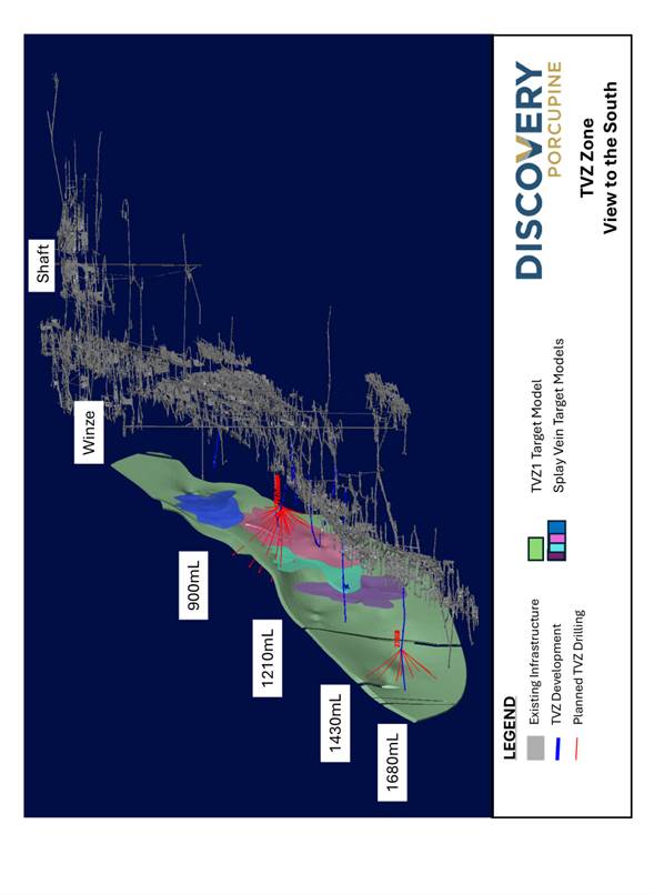
TVZ Project
Drilling commenced at the TVZ Project at the end of October. TVZ is a significant zone of gold mineralization located between the 800 and 1800 m levels in the southeast portion of the Hoyle Pond Mine (Figure 8).
Geologically, TVZ lies in the Porcupine sediments south of the Hoyle Pond Volcanic Belt, just east of the 1060 fault. Gold mineralization is closely associated with a northeast trending steeply dipping shear zone with local splay veins, which plunge moderately to the northeast. The bulk of the mineralization identified to date occurs within a panel measuring approximately 600 m long by 200 m in height, extending from the 850 level to just below the 1410 level, with the best grades typically having a strong correlation with increased amounts of quartz veining, pyrite and arsenopyrite.
Past work at the project includes 437 holes (172,319 m) of wide-spaced drilling from three main platforms on the 900, 1210 and 1410 levels, as well as limited development, mapping, chip sampling and metallurgical test work on the 1210 level. Results from the drilling, mapping and chip sampling have been positive and indicate multiple holes with grades exceeding 5.0 gpt over widths of 5 to 10 m. The results also indicate positive results from the two deepest holes to test the zone to date, holes 21009 and 21094, with returned values of 6.29 gpt over 5.3m and 4.98 gpt over 4.0m, respectively, between the 1550 and 1610 levels. As a result, the potential to extend the zone to greater depths is considered excellent.
Results of the past metallurgical work indicate a strong correlation of gold with arsenopyrite and variable recoveries, but with the potential for improvement using enhanced processing.
The current work program is designed to infill and expand the TVZ Zone in preparation for an initial NI 43-101 mineral resource. The program is targeted to include a minimum of 25,000 m of new drilling from the 900, 1210, 1410 and 1680 levels by the end of the first quarter of 2026.
Drilling is being conducted using one drill located on the 1680 level, which is testing the projected extension of the TVZ Zone down plunge from the 1410 level. Two additional drills are in the process of being mobilized on the 1210 level that will conduct infill and expansion drilling near the mid-point of the historic work.
QUALIFIED PERSONS
Discovery’s exploration programs at the Porcupine operations are conducted under the supervision of Eric Kallio, P.Geo., Senior Vice President, Exploration, Kara Byrnes, P.Geo, Vice President, Exploration and Geology – Porcupine and Craig Yuill, P.Geo., Exploration Manager. Mr. Kallio, Ms. Byrnes and Mr. Yuill are “qualified persons” for the purpose of National Instrument 43-101, Standards of Disclosure for Mineral Projects, of the Canadian Securities Administrators, and have reviewed and approved the scientific and technical information in this news release.
Readers are referred to the mineral resource estimate as set out in the Company’s current technical report entitled “Porcupine Complex, Ontario, Canada NI 43-101 Report on Preliminary Assessment” with an effective date of January 13, 2025, which is available under the Company’s issuer profile on SEDAR+ at www.sedarplus.ca. Statements concerning mineral resource estimates may also be deemed to constitute forward looking information to the extent that they involve estimates of the mineralization that will be encountered if the property is developed. The Technical Report includes the results of a preliminary economic assessment which is preliminary in nature. It includes inferred mineral resources that are considered too speculative geologically to have the economic considerations applied to them that would enable them to be categorized as mineral reserves and there is no certainty that the preliminary economic assessment will be realized.
QA/QC CONTROLS
The Company follows a quality assurance and control (“QA/QC”) program to ensure that sampling and analysis of all exploration work is conducted in accordance with best practices.
At Borden, samples are logged and sampled in a secure facility in Chapleau, Ontario and under supervision of Qualified Geologists. NQ sized core is predominantly sawn in half with one half of the core prepared for shipment, the other half of core retained for future assay verification. Certified reference material (CRM) standards, coarse blank material and duplicates are inserted every 20 samples. Core samples are picked up by Activation Laboratories and tracked via a chain of custody from site to the certified off-site analytical laboratory for preparation and assaying.
At Pamour, core is logged and sampled in a secure facility at the Hoyle Pond mine site and under supervision of Qualified Geologists. The NQ sized core is predominantly whole core sampled with select holes being sawn in half for future verification. CRM standards, coarse blank material and duplicates are inserted every 20 samples. Samples are picked up by Activation Laboratories and tracked via a chain of custody from site to the lab for preparation and assaying.
At Hoyle Pond, core is logged and sampled in a secure facility at the Hoyle Pond mine site and under supervision of Qualified Geologists. The NQ sized drill core is predominantly sawn in half with one half of the core prepared for shipment, the other half of core retained for future assay verification. CRM standards, coarse blank material and duplicates are inserted every 20 samples. Core samples are picked up by Activation Laboratories at the Hoyle Pond facility and tracked via a chain of custody from site to the lab for preparation and assaying.
At Owl Creek, all new drill core collected by Discovery is logged and sampled in a secure facility at the Hoyle Pond mine site and under supervision of Qualified Geologists. The NQ sized drill core is predominantly sawn in half with one half of the core prepared for shipment, the other half of core retained for future assay verification. CRM standards, coarse blank material and duplicates are inserted every 20 samples. Core samples are picked up by Activation Laboratories at the Hoyle Pond facility and tracked via a chain of custody from site to the lab for preparation and assaying.
Procedures for historic drill core from Owl Creek varied with time and is poorly documented due to the long history and varied ownership. Past owners include: Inco (1969 to 1979), Falconbridge (1979 to 1989), Kinross (1993-2002), Porcupine Joint Venture and Goldcorp (2002-2019) and Newmont Corporation (2019 to 2025). For holes from prior to 2006, the drill core was logged onto paper logs and sampling was by whole core methods. Logging of most holes after 1993 was captured electronically, but sampling was still done using whole core methods. Details regarding labs used for assaying, sample security and QAQC are unavailable for most holes prior to 2002 and it appears that the only checks carried out for most assaying was done internally by the Labs themselves. Drill core from 1993 to 2002 was processed mainly at Swasitka Laboratories with portions going to the Macassa Mine and the Bell Creek Mine Laboratories using fire assaying and again relying mostly on internal protocols for QAQC. Drill core from 2002 to 2025 was processed at several laboratories including X-RAL Laboratories, ALS Laboratories and AGAT and the Dome Mine Laboratory using the fire assaying and enhanced protocols for QAQC with insertion of independent blanks and standards.
Discovery utilizes the accredited external lab Activation Laboratories to manage its core analysis. ActLabs is certified by the Standards Council of Canada (SCC) which conforms with ASB-RG Mineral Analysis Laboratory for the Accreditation of Mineral Analysis Testing Laboratories and CAN-P-4E ISO/IEC 17025: General Requirements for the Competence of Testing and Calibration Laboratories.
Sample preparation includes crushing drill core up to 80% passing 2 mm, riffle splitting 500 grams and pulverizing to 95% passing 105 µm followed by both scheduled and specifically requested silica sand cleaning. Gold Analysis involves Fire Assay – Atomic Absorption (AA) technique from a 50-gram pulp sample with grade ranges between 5 to 10,000 ppb. Samples greater than 10,000 ppb are analyzed with a gravimetric finish. Selected high grade samples are also analyzed using the screen metallics procedure.
ABOUT DISCOVERY
Discovery is a growing North American-focused precious metals company. The Company has exposure to silver through its first asset, the 100%-owned Cordero project, one of the world’s largest undeveloped silver deposits, which is located close to infrastructure in a prolific mining belt in Chihuahua State, Mexico. On April 15, 2025, Discovery completed the acquisition of the Porcupine Complex from Newmont Corporation, transforming the Company into a new Canadian gold producer with multiple operations in one of the world’s most renowned gold camps in and near Timmins, Ontario. Discovery owns a dominant land position within the camp, with a large base of Mineral Resources remaining and substantial growth and exploration upside.
On Behalf of the Board of Directors,
Tony Makuch, P. Eng
President, CEO & Director
For further information contact:
Mark Utting, CFA
SVP Investor Relations
Phone: 416-806-6298
Email: mark.utting@discoverysilver.com
Website: www.discoverysilver.com
CAUTIONARY STATEMENT REGARDING FORWARD-LOOKING INFORMATION
This news release may include forward-looking statements that are subject to inherent risks and uncertainties. All statements within this news release, other than statements of historical fact, are to be considered forward looking. Although Discovery believes the expectations expressed in such forward-looking statements are based on reasonable assumptions, such statements are not guarantees of future performance and actual results or developments may differ materially from those described in forward-looking statements. Statements include but are not limited to the resource conversion and expansion drilling at Hoyle Pond, Borden and Pamour mine sites, the high-grade mineralization potential from Owl Creek, located within close proximity to Hoyle Pond; the anticipated results and timing associated with the updated exploration program at the Porcupine Complex; the ability to make new discoveries across the broader property; the ability to complete and the anticipated benefits associated from the development of the Dome and TVZ work programs; the timing associated with a new mineral resource update planned in 2026 and the anticipated benefits thereof; the ability to convert and extend mineral resources at Pamour; the development of the Porcupine Operations and its attractive economics and significant exploration upside; construction decision and development, the results of the Technical Report and the anticipated capital and operating costs, sustaining costs, net present value, internal rate of return, the method of mining the Porcupine Operations, payback period, process capacity, average annual metal production, average process recoveries, concession renewal, permitting of the assets, anticipated mining and processing methods, feasibility study production schedule and metal production profile, anticipated construction period, anticipated mine life, expected recoveries and grades, anticipated production rates, infrastructure, social and environmental impact studies, the completion of key de-risking items, including the timing of receipt permits, availability of water and power, availability of labour, job creation and other local economic benefits, tax rates and commodity prices that would support development of the Project, and other statements that express management's expectations or estimates of future performance, operational, geological or financial results Information concerning mineral resource/reserve estimates and the economic analysis thereof contained in the results of the feasibility study are also forward-looking statements in that they reflect a prediction of the mineralization that would be encountered, and the results of mining, if a mineral deposit were developed and mined. Forward-looking statements are statements that are not historical facts which address events, results, outcomes or developments that the Company expects to occur. Forward-looking statements are based on the beliefs, estimates and opinions of the Company’s management on the date the statements are made and they involve a number of risks and uncertainties.
Factors that could cause actual results to differ materially from those described in forward-looking statements include the completion of the drill programs and the results thereon, the ability to complete the required drilling on a timely basis and the impact of the completion of such drill programs on the ability for the Company to prepare an updated resource estimate in 2026; fluctuations in market prices, including metal prices, continued availability of capital and financing, and general economic, market access restrictions or tariffs, changes in U.S. laws and policies regarding regulating international trade, including but not limited to changes to or implementation of tariffs, trade restrictions, or responsive measures of foreign and domestic governments, changes to cost and availability of goods and raw materials, along with supply, logistics and transportation constraints, changes in general economic conditions including market volatility due to uncertain trade policies and tariffs, , the actual results of current and future exploration activities; changes to current estimates of mineral reserves and mineral resources; conclusions of economic and geological evaluations; changes in project parameters as plans continue to be refined; the speculative nature of mineral exploration and development; risks in obtaining and maintaining necessary licenses, permits and authorizations for the Company’s development stage and operating assets; the accuracy of historical and forward-looking operational and financial information estimates provided by Newmont; the Company’s ability to integrate the Porcupine Operations; statements regarding the Porcupine Operations, including the results of technical studies and the anticipated capital and operating costs, sustaining costs , internal rate of return, concession or claim renewal, the projected mine life and other attributes of the Porcupine Operations, including net present value, the timing of any environmental assessment processes, reclamation obligations; operations may be exposed to new diseases, epidemics and pandemics, including any ongoing or future effects of COVID-19 (and any related ongoing or future regulatory or government responses) and its impact on the broader market and the trading price of the Company’s shares; provincial and federal orders or mandates (including with respect to mining operations generally or auxiliary businesses or services required for operations) in Canada and Mexico, all of which may affect many aspects of the Company's operations including the ability to transport personnel to and from site, contractor and supply availability and the ability to sell or deliver mined silver; changes in national and local government legislation, controls or regulations; failure to comply with environmental and health and safety laws and regulations; labour and contractor availability (and being able to secure the same on favourable terms); disruptions in the maintenance or provision of required infrastructure and information technology systems; fluctuations in the price of gold or certain other commodities such as, diesel fuel, natural gas, and electricity; operating or technical difficulties in connection with mining or development activities, including geotechnical challenges and changes to production estimates (which assume accuracy of projected ore grade, mining rates, recovery timing and recovery rate estimates and may be impacted by unscheduled maintenance); changes in foreign exchange rates (particularly the Canadian dollar, U.S. dollar and Mexican peso); the impact of inflation; geopolitical conflicts; employee and community relations; the impact of litigation and administrative proceedings (including but not limited to mining reform laws in Mexico) and any interim or final court, arbitral and/or administrative decisions; disruptions affecting operations; availability of and increased costs associated with mining inputs and labour; delays in construction decisions and any development of the Porcupine Operations; changes with respect to the intended method of mining and processing ore from the Porcupine Operations; inherent risks and hazards associated with mining and mineral processing including environmental hazards, industrial accidents, unusual or unexpected formations, pressures and cave-ins; the risk that the Company’s mines may not perform as planned; uncertainty with the Company's ability to secure additional capital to execute its business plans; contests over title to properties; expropriation +or nationalization of property; political or economic developments in Canada and Mexico and other jurisdictions in which the Company may carry on business in the future; increased costs and risks related to the potential impact of climate change; the costs and timing of exploration, construction and development of new deposits; risk of loss due to sabotage, protests and other civil disturbances; the impact of global liquidity and credit availability and the values of assets and liabilities based on projected future cash flows; risks arising from holding derivative instruments; and business opportunities that may be pursued by the Company. There can be no assurances that such statements will prove accurate and, therefore, readers are advised to rely on their own evaluation of such uncertainties. Discovery does not assume any obligation to update any forward-looking statements except as required under applicable laws. The risks and uncertainties that may affect forward-looking statements, or the material factors or assumptions used to develop such forward-looking information, are described under the heading "Risks Factors" in the Company’s Annual Information Form dated March 26, 2025, and the Company’s technical report (the “Technical Report”) entitled “Porcupine Complex, Ontario, Canada NI 43-101 Report on Preliminary Assessment” with an effective date of January 13, 2025, which is available under the Company’s issuer profile on SEDAR+ at www.sedarplus.ca.
|
Table 1: Intercepts from Hoyle Pond Underground Mine1,2 | |||||||
| Hole ID | Total Hole Depth |
From | To | Core length |
Estimated True Width |
Au | Notes |
| (m) | (m) | (m) | (m) | (g/t) | |||
| 27651 | 410 | 358.0 | 358.8 | 0.8 | 0.8 | 0.13 | NSV |
| 27652 | 450 | 381.9 | 383.1 | 1.2 | 1.2 | 0.13 | NSV |
| 27653 | 411 | 385.0 | 388.0 | 3.0 | 2.9 | 35.98 | Visible Gold |
| 27657 | 477 | ||||||
| 472.4 | 473.9 | 1.5 | 1.3 | 150.00 | Visible Gold | ||
| incl | |||||||
| 472.8 | 473.3 | 0.5 | 0.4 | 302.00 | |||
| 27654 | 430 | 373.6 | 375.4 | 1.8 | 1.5 | 8.67 | Visible Gold |
| incl | |||||||
| 374.7 | 375.4 | 0.7 | 0.7 | 19.90 | |||
| 27660 | 430 | 376.0 | 377.0 | 1.0 | 1.0 | 75.50 | Visible Gold |
| 379.4 | 382.0 | 2.6 | 2.3 | 11.65 | |||
| incl | |||||||
| 379.4 | 379.8 | 0.4 | 0.4 | 31.30 | |||
| incl | |||||||
| 381.5 | 382.0 | 0.5 | 0.5 | 30.40 | |||
| 27656 | 445.7 | NSV | |||||
| 27662 | 420 | 364.6 | 366.4 | 1.8 | 1.7 | 44.54 | Visible Gold |
| 27682 | 501 | 471.1 | 479.8 | 8.7 | 7.1 | 23.95 | Visible Gold |
| 27664 | 450 | 393.7 | 395.4 | 1.7 | 1.5 | 9.55 | Visible Gold |
| incl | |||||||
| 394.7 | 395.1 | 0.4 | 0.4 | 36.30 | |||
| 27701 | 411 | 363.7 | 365.8 | 2.1 | 1.8 | 86.09 | Visible Gold |
| Incl | |||||||
| 363.7 | 364.2 | 0.5 | 0.4 | 360.00 | |||
| 365.8 | 379.1 | 13.3 | 11.5 | 9.88 | |||
| 27663 | 474 | NSV | |||||
| 27661 | 450 | NSV | |||||
- All assays are reported uncut.
- Intervals are reported using both true widths and core lengths.
|
Table 2: Intercepts from Borden Underground Mine1,2 | |||||||||||
| Hole ID | Total Hole Depth |
From | To | Core length |
Estimated True Width |
Au | Notes | ||||
| (m) | (m) | (m) | (m) | (g/t) | |||||||
| 585-00099 | 234.0 | 200.7 | 206.8 | 6.1 | 5.2 | 11.48 | |||||
| Incl | |||||||||||
| 203.0 | 206.8 | 3.8 | 3.2 | 15.49 | |||||||
| 585-00101 | 215.4 | 190.6 | 198.8 | 8.2 | 6.8 | 6.14 | |||||
| 585-00102 | 200.0 | 177.6 | 192.0 | 14.4 | 12.6 | 9.41 | |||||
| incl | |||||||||||
| 185.2 | 191.2 | 6.0 | 5.2 | 19.29 | |||||||
| 585-00104 | 220.0 | 181.0 | 185.6 | 4.6 | 3.7 | 3.11 | |||||
| 585-00105 | 190.0 | 162.9 | 173.3 | 10.4 | 9.1 | 3.24 | |||||
| incl | |||||||||||
| 168.1 | 173.3 | 5.2 | 4.5 | 4.20 | |||||||
| 585-00106 | 190.0 | 168.35 | 175.1 | 6.8 | 6.3 | 6.57 | |||||
| Incl | |||||||||||
| 171 | 175.1 | 4.1 | 3.8 | 10.10 | |||||||
| 585-00128 | 226.0 | 203.3 | 210.0 | 6.7 | 6.3 | 7.49 | |||||
| Incl | |||||||||||
| 203.7 | 207.3 | 3.6 | 3.4 | 11.01 | |||||||
| 585-00107 | 197.0 | 167.0 | 178.4 | 11.0 | 10.2 | 4.21 | |||||
| Incl | |||||||||||
| 170.73 | 175.8 | 5.1 | 4.6 | 7.04 | |||||||
| 585-00100 | 217.0 | 153.7 | 165.2 | 11.5 | 9.9 | 4.91 | |||||
| incl | |||||||||||
| 154.4 | 163.5 | 9.1 | 7.9 | 5.30 | |||||||
| 182.0 | 187.4 | 5.4 | 4.9 | 7.27 | |||||||
| incl | |||||||||||
| 183.3 | 186.9 | 3.6 | 3.2 | 8.78 | |||||||
| 585-00103 | 236.0 | NSV | |||||||||
| 585-00111 | 235.0 | NSV | |||||||||
| 585-00124 | 279.0 | 238.2 | 244.7 | 6.5 | 5.2 | 4.91 | |||||
| incl | |||||||||||
| 239.5 | 244.7 | 5.2 | 4.1 | 5.85 | |||||||
| 585-00125 | 213.6 | 193.4 | 200.0 | 6.6 | 6.0 | 15.61 | |||||
| 585-00159 | 284.2 | 248.6 | 256.0 | 7.4 | 6.9 | 13.88 | |||||
| incl | |||||||||||
| 248.6 | 253.8 | 5.2 | 4.8 | 18.99 | |||||||
| 585-00160 | 322.0 | 281.0 | 287.0 | 6.0 | 5.2 | 9.99 | |||||
| 585-00127 | 217.6 | 182.4 | 210.6 | 28.3 | 23.1 | 6.15 | |||||
| Incl | |||||||||||
| 191.2 | 199.0 | 7.8 | 6.4 | 13.21 | |||||||
| 585-00234 | 250.1 | 179.1 | 188.0 | 8.9 | 7.4 | 5.15 | |||||
| 208.7 | 213.3 | 4.6 | 3.7 | 4.91 | |||||||
| Incl | |||||||||||
| 209.4 | 212.4 | 3.0 | 2.5 | 6.93 | |||||||
| 585-00123 | 209.9 | 176.6 | 188.5 | 11.2 | 10.9 | 7.60 | |||||
| incl | |||||||||||
| 176.6 | 182.4 | 5.7 | 5.3 | 11.34 | |||||||
| 192.0 | 202.6 | 10.1 | 8.9 | 3.85 | |||||||
| incl | |||||||||||
| 193.9 | 196.4 | 2.5 | 2.2 | 8.89 | |||||||
| 585-00126 | 223.5 | 199.0 | 208.0 | 8.9 | 8.5 | 8.20 | |||||
| Incl | |||||||||||
| 203.12 | 207.97 | 4.9 | 4.6 | 11.52 | |||||||
- All assays are reported uncut.
- Intervals are reported using both core length and true width.
|
Table 3: Intercepts from the Pamour Open Pit Mine1,2 |
||||||||
| Hole ID | Total hole Depth | From | To | Core length | Au | Notes | ||
| (m) | (m) | (m) | (g/t) | |||||
| PAM25-0001 | 408 | 121.5 | 132.8 | 11.3 | 0.81 | 4.93gpt/1.5m | ||
| 152.3 | 178.9 | 26.6 | 0.92 | 4.71gpt/0.7m | ||||
| 6.14gpt/0.5m 4.85gpt/0.5m |
||||||||
| 387.8 | 397 | 9.2 | 0.96 | |||||
| 4.80gpt/1.0m | ||||||||
| PAM25-0002 | 423 | 163.0 | 185.5 | 22.5 | 0.80 | |||
| 6.28gpt/1.0m | ||||||||
| 220.0 | 232.9 | 12.9 | 0.71 | |||||
| 359.0 | 375.0 | 16.0 | 1.56 | |||||
| 6.14gpt/1.0m 4.50gpt / 0.5m |
||||||||
| 7.68gpt/0.5m | ||||||||
| 4.42gpt/0.6m | ||||||||
| PAM25-0003 | 416.0 | 314.0 | 324.0 | 10.0 | 0.89 | |||
| PAM25-0005 | 315.0 | 202.0 | 246.9 | 44.9 | 1.40 | |||
| 6.26gpt / 0.3m 6.43gpt / 0.3m 6.03gpt / 0.5m 4.64gpt / 1.0m 12.30gpt / 0.6m 4.64gpt / 0.8m 12.00gpt / 0.6m |
||||||||
| PAM25-0006ALR | 132 | 64.5 | 72.9 | 8.4 | 0.75 | |||
| 114.6 | 127.8 | 13.2 | 1.68 | 8.90gpt/0.4m | ||||
| 6.60gpt/0.8m | ||||||||
| PAM25-0006LR | 138 | 67.0 | 87.0 | 20.0 | 0.68 | |||
| 115.5 | 130.9 | 15.4 | 0.81 | |||||
| PAM25-0008 | 148 | 63.6 | 72.0 | 8.4 | 1.05 | |||
| 142.7 | 148.6 | 5.9 | 0.83 | |||||
| PAM25-0010 | 315 | 189.8 | 224.0 | 34.2 | 1.51 | 6.04 gpt/1.0m | ||
| PAM25-0012 | 435 | 189.9 | 244.4 | 54.5 | 1.07 | 142.00gpt/0.3m | ||
| 261.4 | 366.0 | 104.6 | 1.44 | 5.85 gpt/0.3m | ||||
| 31.90 gpt/1.1m | ||||||||
| 61.70 gpt/0.6m | ||||||||
| 10.60 gpt/0.7m | ||||||||
| 9.03 gpt/0.3m | ||||||||
| 12.00gpt/0.4m | ||||||||
| PAM25-0013 | 91.5 | 65.0 | 77.0 | 12.0 | 0.79 | 5.27gpt / 0.4m | ||
| PAM25-0014 | 486.2 | 103.2 | 124.6 | 21.4 | 0.74 | 12.00gpt / 0.8 m | ||
| 7.60gpt / 0.5 m | ||||||||
| PAM25-0016 | 111 | 32.0 | 49.2 | 17.2 | 0.63 | Hole did not go to full planned depth due to breakthrough | ||
| PAM25-0018 | 267 | 25.1 | 45.0 | 19.9 | 3.42 | 6.90gpt / 5.5m | ||
| 105.8 | 117.6 | 11.8 | 0.49 | |||||
| 159.0 | 216.6 | 57.6 | 1.47 | 17.00gpt / 1.3 m | ||||
| 9.50gpt / 1.0 m | ||||||||
| 17.10gpt / 0.3 m | ||||||||
| 6.70gpt / 0.8 m | ||||||||
| 11.40gpt / 0.7 m | ||||||||
| 10.00gpt / 0.3 m | ||||||||
| 9.20gpt / 0.5m | ||||||||
| PAM25-0009 | 351 | 93.1 | 99.5 | 6.4 | 0.96 | 5.60gpt / 0.8m | ||
| 117.5 | 130.7 | 13.2 | 0.61 | |||||
| 168.8 | 194.6 | 25.8 | 2.03 | 8.5 gpt / 0.3m | ||||
| 10.5 gpt / 0.3 m | ||||||||
| 6.19 gpt / 0.8 m | ||||||||
| 17.70gpt / 0.7m | ||||||||
| 205.0 | 225.5 | 20.5 | 2.18 | 6.00 gpt / 1.0 m | ||||
| 10.50gpt / 0.3m | ||||||||
| 11.70gpt / 1.4m | ||||||||
| 247.8 | 256.0 | 8.2 | 0.99 | |||||
| 264.8 | 302.6 | 37.8 | 1.20 | 11.80gpt / 0.6 m 9.70gpt / 0.6 m 5.90gpt / 0.9 m |
||||
| PAM25-0011 | 432 | 202.8 | 243.7 | 40.9 | 1.32 | 6.40 gpt / 0.6 m 6.10 gpt / 1 m 6.40gpt / 0.3 m 8.50 gpt / 0.9 m |
||
| 282.0 | 289.0 | 7.0 | 0.69 | |||||
| 297.0 | 304.5 | 7.5 | 2.18 | 12.80gpt / 1.0m | ||||
| PAM25-0019 | 330 | 208.0 | 245.0 | 37.0 | 1.74 | 15.60gpt / 1.0m | ||
| 282.0 | 301.8 | 19.8 | 0.50 | |||||
| PAM25-0021 | 255 | 31.3 | 40.2 | 8.9 | 2.08 | 4.90gpt / 1.0m | ||
| 57.0 | 63.6 | 6.6 | 1.37 | 12.10gpt /0.6 m | ||||
| 99.6 | 104.7 | 5.1 | 0.87 | 4.80gpt / 0.6 m | ||||
| 139.0 | 144.5 | 5.5 | 1.43 | |||||
| 158.5 | 180.3 | 21.8 | 0.74 | 4.80 gpt / 0.7 m | ||||
| 198.0 | 226.0 | 28.0 | 1.02 | 14.10gpt / 0.6 m | ||||
| 6.80gpt / 0.7 m | ||||||||
| PAM25-0025 | 300 | 92.5 | 99.9 | 7.4 | 3.46 | 37.70gpt / 0.5m | ||
| 223.2 | 263.0 | 39.8 | 3.40 | 6.00 gpt / 14.7m | ||||
| 5.40 gpt / 0.4m | ||||||||
| 8.10 gpt / 1.0m | ||||||||
| 5.90 gpt / 0.5m | ||||||||
| 291.0 | 298.5 | 7.5 | 1.48 | 4.50gpt /0.5 m | ||||
| PAM25-0033 | 375 | 76.0 | 81.5 | 5.5 | 0.82 | 5.50 gpt /0.3m | ||
| 180.0 | 187.0 | 7.0 | 2.52 | 56.40gpt /0.3m | ||||
| PAM25-0029 | 340 | 82.0 | 113.5 | 31.5 | 0.68 | |||
| 186.0 | 214.0 | 28.0 | 0.73 | |||||
| PAM25-0020 | 456 | 112.4 | 117.8 | 5.4 | 0.91 | 15.90 gpt/ 0.3m | ||
| 127.4 | 133.5 | 6.1 | 0.61 | 5.66 gpt/ 0.3m | ||||
| 193.5 | 199.3 | 5.8 | 0.80 | 6.08 gpt / 0.4m | ||||
| 280.2 | 303.0 | 22.8 | 0.89 | 9.96 gpt / 0.5 m | ||||
| 17.50 gpt / 0.6 m | ||||||||
| 326.5 | 332.7 | 6.2 | 1.91 | 34.90 gpt / 0.3m | ||||
| 382.0 | 412.0 | 24.0 | 1.04 | 12.50gpt / 1.0m | ||||
| 8.66 gpt / 0.4m | ||||||||
| 5.55 gpt / 0.4m | ||||||||
| PAM25-0007 | 402 | 226.5 | 271.2 | 44.7 | 0.87 | 14.60gpt / 0.7m | ||
| 379.9 | 394.5 | 6.0 | 4.14 | 24.00gpt / 0.8 m | ||||
| PAM25-0031 | 339 | 217.5 | 244.8 | 27.3 | 1.30 | 8.30gpt / 1.0 m | ||
| PAM25-0024 | 264 | 26.5 | 42.0 | 15.5 | 1.35 | 5.31gpt / 0.3 m | ||
| 89.0 | 96.0 | 7.0 | 3.15 | 16.60 gpt / 0.8m | ||||
| 141.1 | 175.7 | 34.6 | 1.85 | 64.70 gpt / 0.4m | ||||
| 21.10 gpt / 0.5m | ||||||||
| 19.20 gpt / 0.5m | ||||||||
| 208.0 | 225.0 | 17.0 | 1.20 | 15.10 gpt / 0.5m | ||||
| PAM25-0034 | 195 | 43.5 | 52.0 | 8.5 | 9.61 | 38.00 gpt / 2.0m | ||
| 67.0 | 86.8 | 19.8 | 0.82 | |||||
| 187.4 | 193.7 | 6.3 | 2.68 | 6.90 gpt / 1.2m | ||||
| PAM25-0036 | 402 | 100.4 | 116.5 | 16.1 | 1.11 | |||
| 297.0 | 324.8 | 27.8 | 0.67 | |||||
| 331.1 | 370.5 | 39.4 | 1.78 | 8.80gpt / 0.6 m | ||||
| 10.20gpt / 0.5 m | ||||||||
| 7.30gpt / 1.0 m | ||||||||
| PAM25-0044 | 291 | 60.9 | 98.0 | 37.1 | 0.93 | 5.62gpt / 0.6 m | ||
| 230.7 | 280.0 | 49.3 | 1.16 | 7.39gpt / 0.4 | ||||
| 5.57 gpt / 0.3 m | ||||||||
| 6.93 gpt / 0.3 m | ||||||||
| 5.74 gpt / 1.0 m | ||||||||
| PAM25-0054 | 327 | 202.6 | 209.6 | 7.0 | 0.89 | |||
| 273.0 | 293.0 | 20.0 | 0.88 | 9.29 gpt / 0.3 m | ||||
| PAM25-0041 | 423 | 394.3 | 398.3 | 5.0 | 48.82 | 396.00 gpt/0.6m | ||
| PAM25-0028 | 283 | 85.0 | 100.3 | 15.3 | 2.48 | |||
| 215.0 | 221.0 | 6.0 | 1.42 | |||||
| 222.0 | 282.5 | 60.5 | 0.97 | |||||
| PAM25-0038 | 300 | 38.7 | 77.0 | 38.3 | 1.51 | |||
| PAM25-0068 | 393 | 212.0 | 298.6 | 86.6 | 0.96 | |||
- All assays are reported uncut.
- Intervals are reported using both true widths and core lengths.
|
Table 4: Intercepts from New Drilling at Owl Creek Project1,2 | |||||||||
| Hole ID | Total Hole Depth |
From | To | Core length |
Estimated True Width |
Au | Notes | ||
| (m) | (m) | (m) | (m) | (g/t) | |||||
| OC25-001 | 824.8 | 670.9 | 687.2 | 16.3 | 4.08 | ||||
| Incl. | |||||||||
| 681.8 | 685.7 | 3.9 | 9.81 | ||||||
| 705.7 | 723.2 | 17.5 | 4.14 | ||||||
| Incl. | |||||||||
| 713.2 | 723.2 | 10.0 | 6.48 | ||||||
| OC25-004A | 1100 | 892.6 | 897.4 | 4.8 | 2.18 | ||||
| 917.0 | 947.5 | 30.5 | 0.48 | ||||||
| Incl | |||||||||
| 928.5 | 933.5 | 5.0 | 1.07 | ||||||
| OC25-005B | 1203 | 813.0 | 822.0 | 9.0 | 4.08 | ||||
| Incl: | |||||||||
| 816.0 | 819.0 | 3.0 | 9.75 | ||||||
| 833.0 | 836.0 | 3.0 | 2.58 | ||||||
| OC25-006 | 930 | 667.3 | 672.5 | 5.2 | 5.58 | ||||
| Incl | |||||||||
| 668.4 | 669.5 | 1.1 | 17.63 | ||||||
| 707.0 | 710.1 | 3.1 | 2.75 | ||||||
| 739.0 | 750.0 | 11.0 | 5.39 | ||||||
| Incl | |||||||||
| 741.5 | 742.0 | 0.5 | 14.20 | ||||||
| 768.0 | 773.1 | 5.1 | 1.68 | ||||||
| OC25-006W1 | 954 | 423.5 | 426.7 | 3.2 | 4.34 | ||||
| including | |||||||||
| 426.4 | 426.7 | 0.3 | 29.50 | ||||||
| 652.0 | 655.0 | 3.0 | 1.91 | ||||||
| 667.5 | 675.0 | 7.5 | 1.28 | ||||||
| 685.0 | 712.0 | 27.0 | 1.93 | ||||||
| including | |||||||||
| 685.5 | 692.8 | 7.3 | 4.04 | ||||||
| 692.8 | 697.0 | 4.2 | 1.89 | ||||||
| 709.5 | 713.0 | 3.5 | 2.73 | ||||||
| including | |||||||||
| 711.1 | 711.5 | 0.4 | 16.20 | ||||||
| OC25-007A | 1285.2 | 383.0 | 390.0 | 7.0 | 2.48 | ||||
| including | |||||||||
| 383.0 | 384.0 | 1.0 | 12.60 | ||||||
| 395.1 | 399.0 | 3.9 | 2.02 | ||||||
| 411.0 | 414.0 | 3.0 | 3.04 | ||||||
| 422.0 | 425.0 | 3.0 | 2.69 | ||||||
| including | |||||||||
| 422.0 | 422.5 | 0.5 | 14.60 | ||||||
- All assays are reported uncut.
-
Intervals are reported using core lengths.
FIGURE 1: HOYLE POND
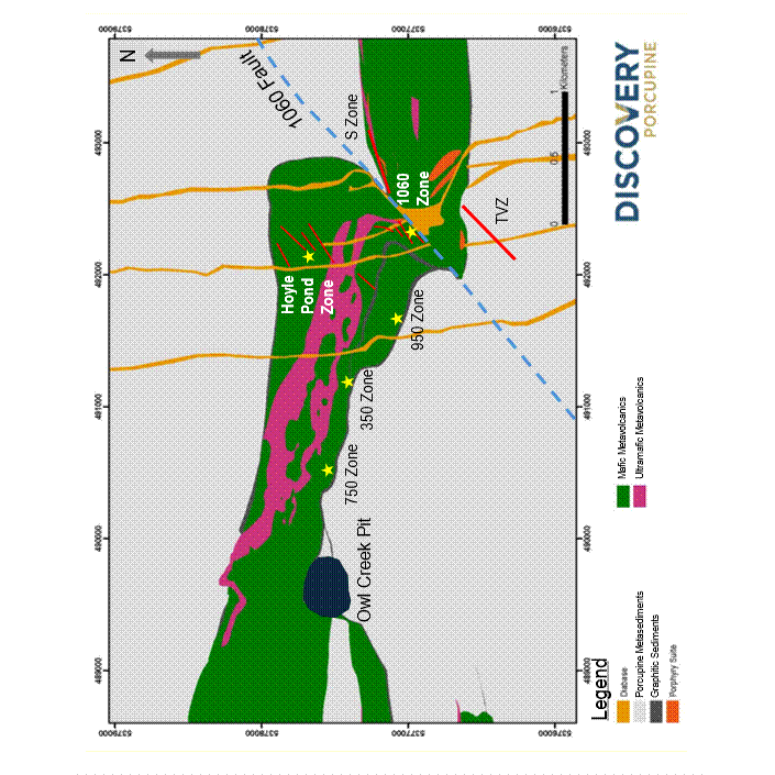
FIGURE 2: HOYLE POND – S ZONE LOWER DRILL RESULTS
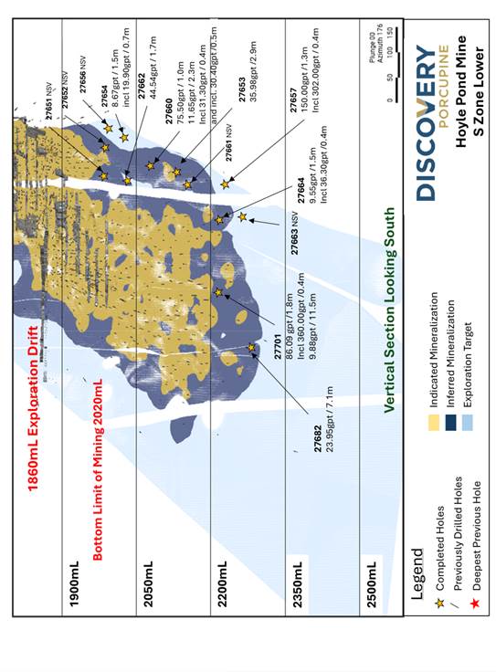
FIGURE 3: BORDEN MINE
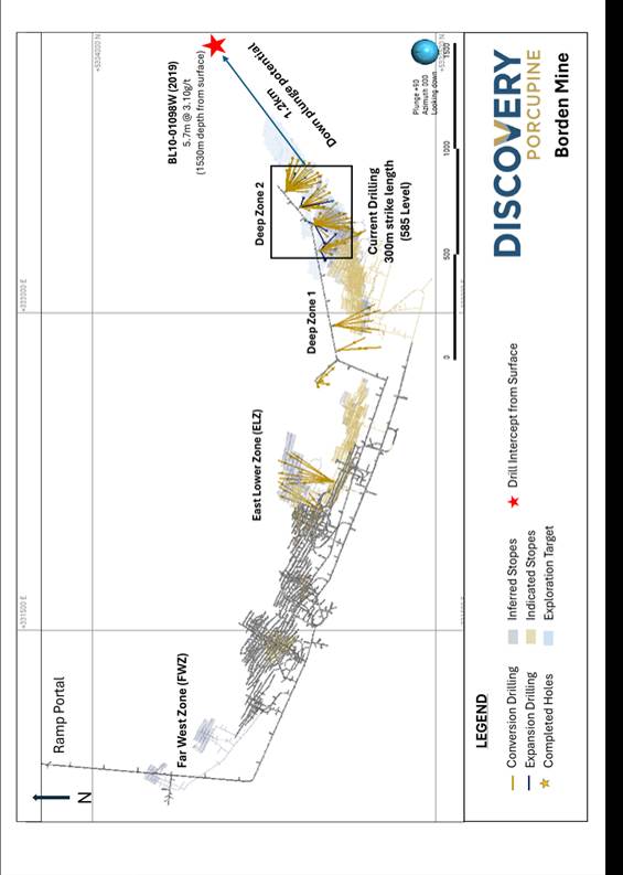
FIGURE 4: BORDEN – DEEP ZONE
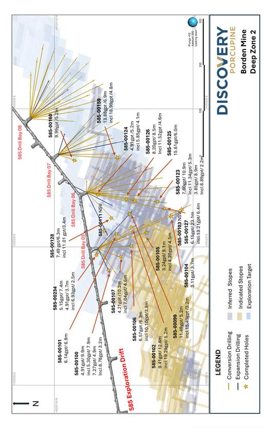
FIGURE 5: PAMOUR
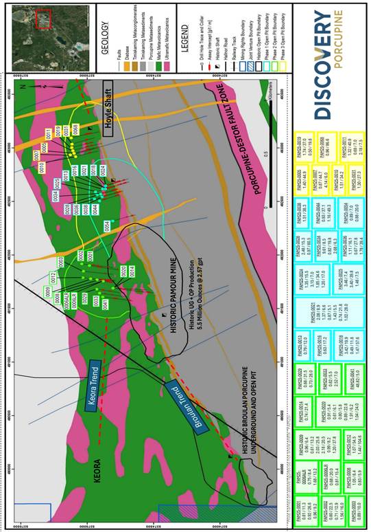
FIGURE 6: OWL CREEK – PLAN VIEW
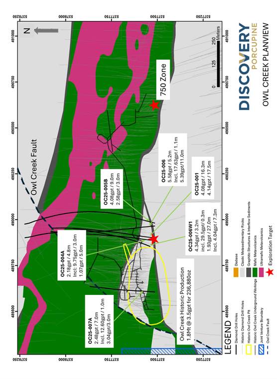
FIGURE 7: DOME
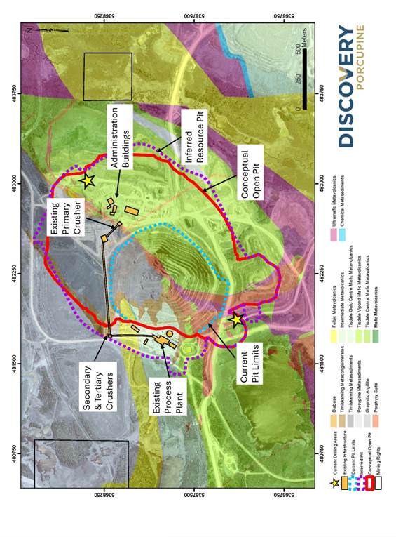
FIGURE 8: TVZ ZONE – VIEW TO SOUTHEAST
Photos accompanying this announcement are available at
https://www.globenewswire.com/NewsRoom/AttachmentNg/a79614df-6720-4372-b490-bdac0a28828c
https://www.globenewswire.com/NewsRoom/AttachmentNg/ef59dac0-6d64-48e5-b113-e08cb6a62d60
https://www.globenewswire.com/NewsRoom/AttachmentNg/938c8fc0-a257-45e0-ab3a-d5d40226b7b7
https://www.globenewswire.com/NewsRoom/AttachmentNg/f205c29b-6b72-4785-a243-d8041bcabe19
https://www.globenewswire.com/NewsRoom/AttachmentNg/5d407ef8-2854-4326-ac16-4907b62c5587
https://www.globenewswire.com/NewsRoom/AttachmentNg/692fbdbf-5f57-4387-921b-6db37db79f14
https://www.globenewswire.com/NewsRoom/AttachmentNg/e8125195-11af-420d-93e9-88330c1101fd
https://www.globenewswire.com/NewsRoom/AttachmentNg/e3aded54-7d2a-4b62-aaf7-7bccc6465ec5

![]()
FIGURE 1: HOYLE POND
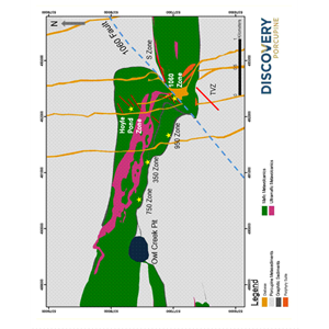
FIGURE 1: HOYLE POND
Figure 2: HOYLE POND – S ZONE LOWER DRILL RESULTS

Figure 2: HOYLE POND – S ZONE LOWER DRILL RESULTS
FIGURE 3: BORDEN MINE
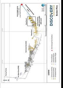
FIGURE 3: BORDEN MINE
FIGURE 4: BORDEN – DEEP ZONE
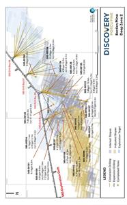
FIGURE 4: BORDEN – DEEP ZONE
FIGURE 5: PAMOUR
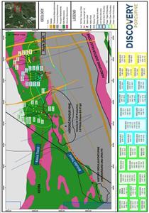
FIGURE 5: PAMOUR
FIGURE 6: OWL CREEK – PLAN VIEW

FIGURE 6: OWL CREEK – PLAN VIEW
FIGURE 7: DOME
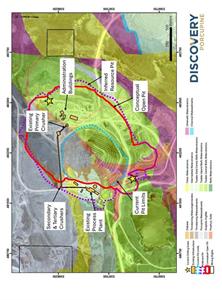
FIGURE 7: DOME
FIGURE 8: TVZ ZONE – VIEW TO SOUTHEAST
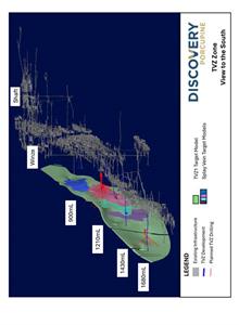
FIGURE 8: TVZ ZONE – VIEW TO SOUTHEAST
Legal Disclaimer:
EIN Presswire provides this news content "as is" without warranty of any kind. We do not accept any responsibility or liability for the accuracy, content, images, videos, licenses, completeness, legality, or reliability of the information contained in this article. If you have any complaints or copyright issues related to this article, kindly contact the author above.
